Figure 1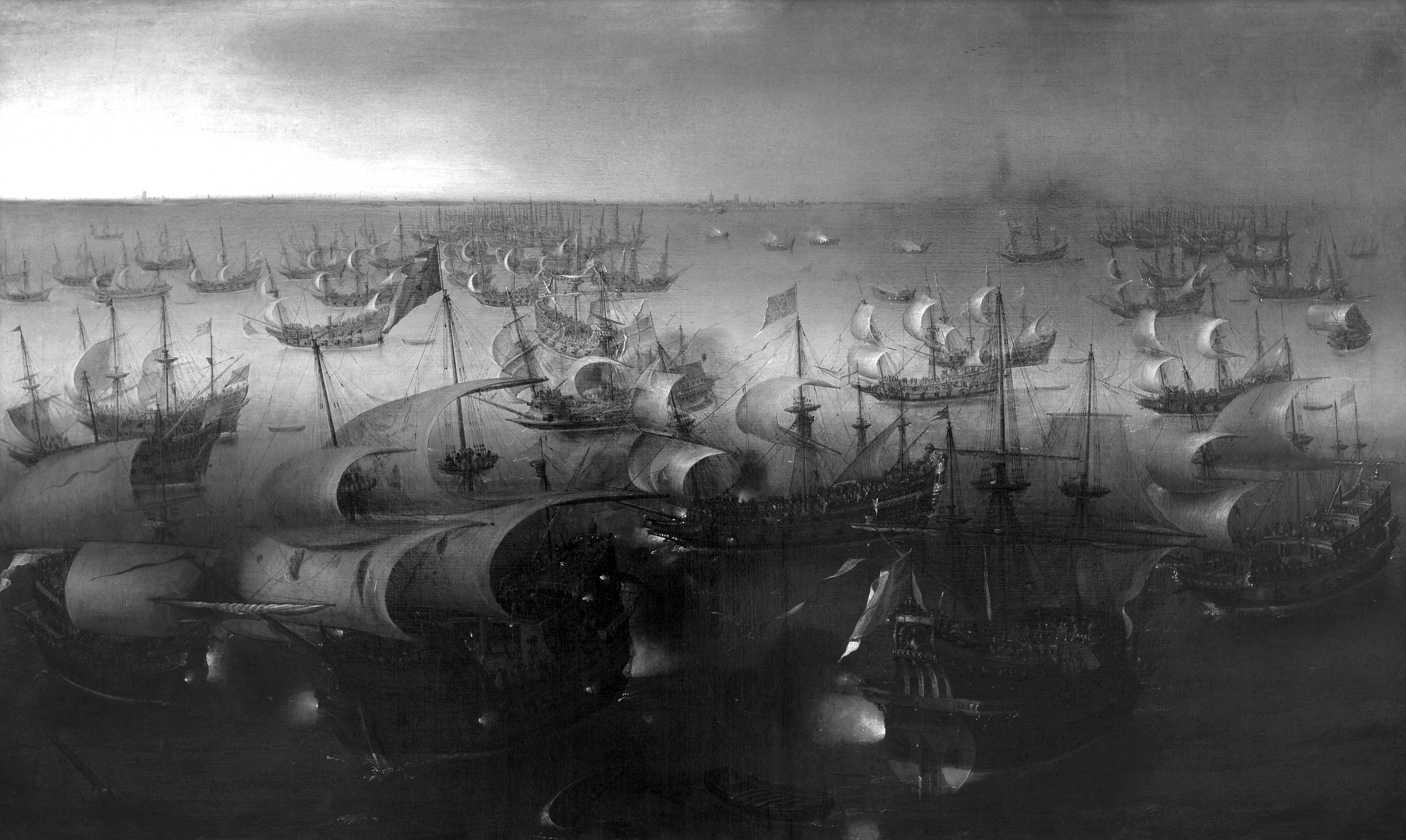 Hendrick Cornelisz. Vroom. The Seventh Day of the Naval Battle between the Spanish Armada and the English Fleet, 1600 or 1601. Oil on canvas, 36 x 60.1 in. (91.4 x 152.8 cm). Tiroler Landesmuseum Ferdinandeum, Innsbruck, Austria.
p. 6
“Maritime Space”
Art history has traditionally understood the invention of the Dutch seascape around 1600 to be the result of a development within the history of style, in the course of which imaginary depth superseded the vertical surface of the image support, the low horizon superseded the cartographic perspective, the realistic representation of nature superseded religious themes, and concealed gradations of space were replaced by the continuous ground of the pictorial field.1 The artist Allan Sekula, however, describes the invention of the seascape as a result of the entry of “maritime space” into history.2 This “maritime space” is not an interior affair of art history but a new order of space in Carl Schmitt’s sense; that is, a new kind of nomos—a nomos of the sea.3 This space is defined, first, by a preindustrial capitalism based on trade and primitive accumulation; second, by a shift of warfare from land to sea as well as by a claim for naval supremacy by the Dutch provinces; third, by cultural techniques like cartography and navigation; and fourth, by the integration of political representation and maritime motifs into a panoramic space. The seascape is not the result of a coming to terms with the problems of representing the immense spatial depth of the sea but is rather the result of a “spatial revolution.” What do we mean when we speak of “space”? Space in general does not exist independently of cultural techniques of space control, and maritime space in particular cannot be separated from the practice of navigation that has disclosed maritime space in the first place.4 “Numberless wonders, terrible wonders walk the world, but none the match for man”—so sings the Theban choir in Sophocles’s Antigone—“that great wonder crossing the heaving gray sea / driven on by the blasts of winter.”5 That great wonder, man, sets out to sea to travel the blackish seas. This setting out to sea is, in Sophocles’s Greek, called chorein. “Poliou péran póntou … chorei.” Chorein is the verb form of chora. As Martin Heidegger emphasizes, chora is not to be mistaken for space in the sense of extension:p. 7
The Greeks had no word for “space.” This is no accident; for they experienced the spatial on the basis not of place (topos); they experienced it as chora, which signifies neither space nor place but that which is occupied by what stands there. The place belongs to the thing itself.6
Chora is that which makes space so that something, a thing, may appear. But it is also the outside of the polis. Choreo, the verb, means “to make place” or “give room,” but it also translates as “passing through, penetrating, traversing successfully.” 7 The chorein of the ships is an act of setting up space, which precedes place and founds the capability-to-be-at-a-place; it is the violence of an original space seizure in placeless realms, which is so terrible because of its immemoriability, a vectorial affect that causes a first striation of the smooth space. The terrible chorein, which introduces a spatiality and a being of things outside the polis, which from the perspective of the polis has to appear as eerie, ghastly, and without rights, constitutes the possibility to rule the placeless as maritime space, to found colonies, to visit foreign coasts, to degustate and trade this year’s wine, or to subdue other peoples.
What can be called with Sophocles the Dutch “chorein” and with Schmitt the Dutch spatial revolution—that is, the fact that a new sovereign state appears as an actor on the stage of world history because a growing alliance of small communities decided to make its fate depend on the conditions and possibilities of maritime space—is brought about by a network of actors in which heterogeneous media of representation; practices of navigation; political, economic, and military strategies; and juridical discourses by and by form a stable dispositif. This chorein of the Dutch inscribed itself in the form of the Dutch seascape of the late-sixteenth, earlyseventeenth century.
The Seabeggars
In 1943 the Tirolean State Museum in Innsbruck, Austria, received as a gift a painting by the Haarlem painter Hendrick Cornelisz. Vroom, The Seventh Day of the Battle between the Spanish Armada and the English Fleet. Vroom painted it probably after his return from England, where he had been introduced to Lord Howard—the English admiral who commanded the English fleet in 1588.8 The painting is signed and can be dated to the year 1600 or 1601. Taking this painting as a starting point, I wish to point out some Figure 2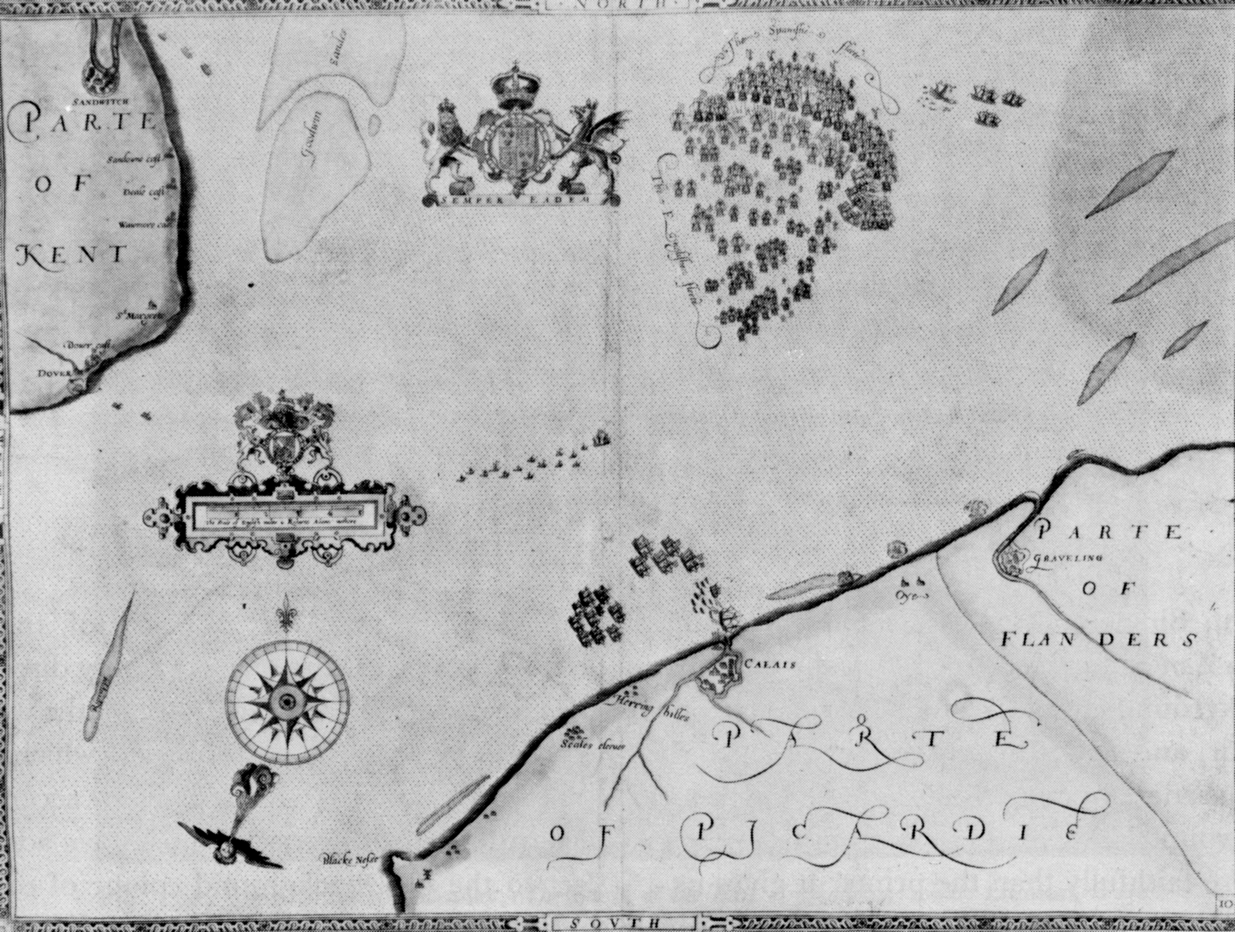 Robert Adams. Expeditionis Hispanorum in Angliam vera discriptio. Anno Do. MDLXXXVIII, 1590. Copper engraving, detail. ideas about the origin of the seascape. Referring ap. 8 piece of painted canvas to a number of military and technical operations against the backdrop of the Dutch spatial revolution brings out the relations among painting, piracy, techniques of navigation, and nation building.
Vroom is said to be the “father” of marine painting. Four years after the victory of the English fleet over the Spanish armada, he was commissioned to provide the designs for a series of huge tapestries showing different episodes of the sea battle. In 1834 these tapestries were destroyed during the burning of the Houses of Parliament, where they had hung for more than two centuries. What separates these tapestries from all later seascapes is the bird’s-eye perspective from which the historical events are seen. Vroom’s designs were the result of an operation of transforming one image medium, the map, into another, the topographic representation of a landscape. Shortly after the sea battle Robert Adams, the “Surveyor of the Queen’s Buildings,” had drawn eleven maps, which charted the successive encounters of the two fleets in the English Channel.9 These maps were given to Vroom, who translated them into ten large cartoons, which both precisely preserved Adams’s cartographic details while transforming the cartographer’s perspective into panoramic views.
Vroom was an expert in transforming cartographic and schematic representations of military operations at sea into topographic and panoramic representations of historical scenarios. Using the armada tapestries and Adams’s schematic charts, the events depicted on the Innsbruck painting can be identified as a detail from the tenth tapestry. Due to a rotation of the viewing direction from north to east-southeast, the coastal strip that appears in the background of Vroom’s painting represents a part of the coast of Flanders between Dunkirk and Ostend.
As a consequence of the prestigious English commission, Vroom was commissioned to complete another series of tapestries in 1595, this time by the Province of Zeeland, whose magistrates wanted to see commemorated their victories over the Spaniards in the early years of the rebellion. The so-called Zeeland or Middelburg tapestries, which were woven according to Vroom’s designs, have been credited as the first Netherlandish seascapes.10 They feature the true agents of the Dutch appropriation of the sea (Seenahme).
The “most terrible wonder,” to speak with Sophocles, that practiced the chorein for the Netherlands in the form of a menace that haunted the seas went by the name of “seabeggars” (watergeuzen). This naval threat helped give birth to the independent union of the General States. Since the modest troops of the rebels had no chance against the army of the Duke of Alba, the rebellion could gain strength andFigure 3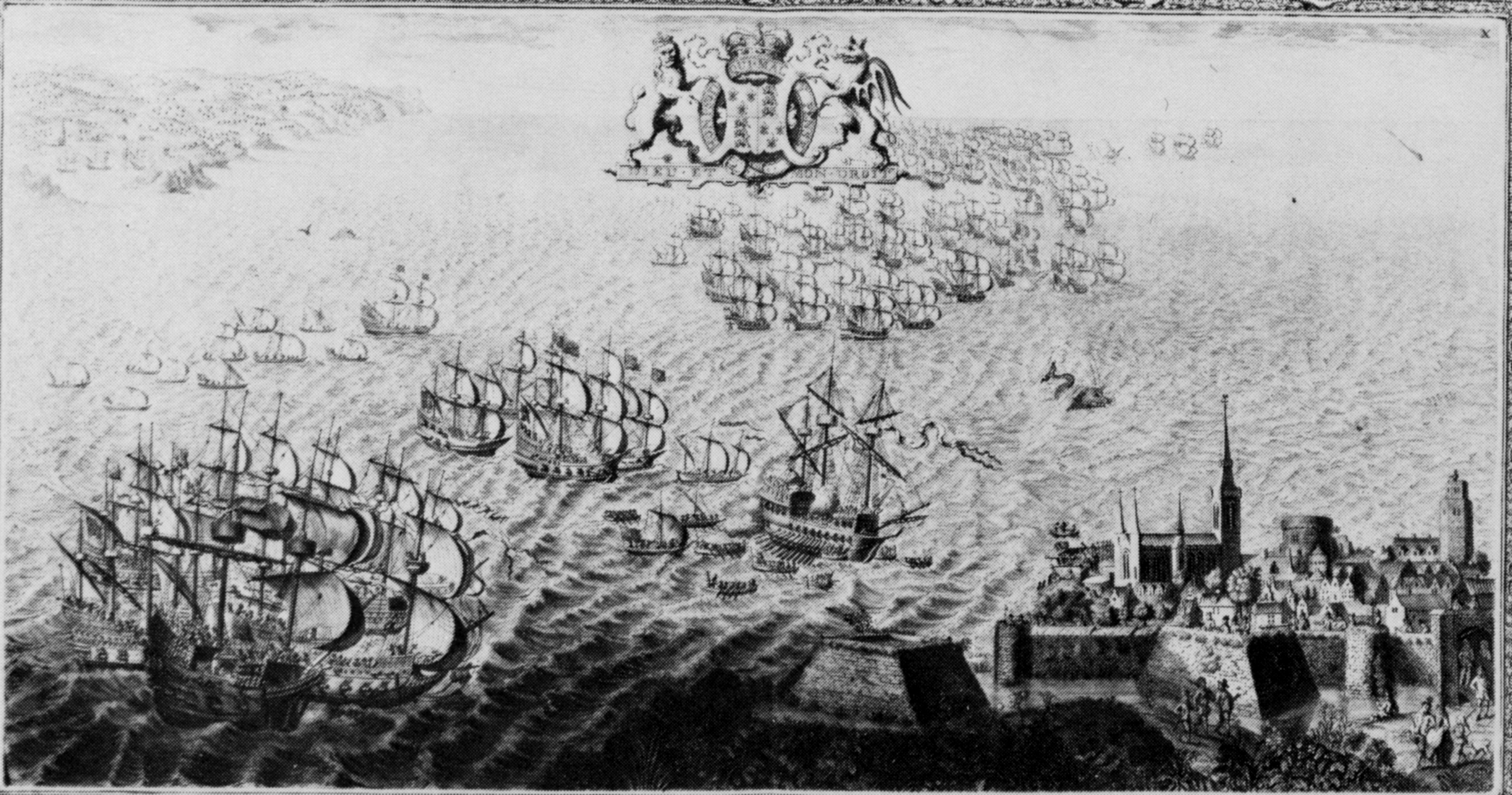 John Pine (engraver and publisher). The Tapestry Hangings of the House of Lords: Representing the Several Engagements between the English and Spanish Fleets in the Ever Memorable Year MDLXXXVIII, 1739. Plate 10: “The Spaniards make the best of their way for the Northern Seas; and… are very much battered by the English, who closely pursue them.” After a tapestry, delivered in 1595, designed by Hendrick Cornelisz. Vroom. p. 9 be effective only by resorting to a kind of warfare that avoided as much as possible battles of decision on land and transferred war instead to the sea, where it took the shape of operations of an ambivalent character that oscillated between warfare and pirate assault. This ambivalent character of the military/piratical actions of the seabeggars reflected the ambivalent character of the field of operations that oscillated between land and sea. In Roman times, Pliny the Elder wrote about the West and East Frisian coast, noting that it consists of a “vast tract of land” that leaves unanswered the question of “whether these regions are to be looked upon as belonging to the land, or whether as forming a portion of the sea.”11 The new sea power of the Netherlands took form not on the high seas but in shallow waters such as gats (estuaries) or vlies (tidal channels) between islands. The form taken by this new power left its trace on the early examples of the seascape.
The seabeggars were Calvinist pirates or freebooters (depending on which political side you were on) who were allies of William of Orange and Ludwig von Nassau-Dillenburg, although they did not always operate under their orders.12 From 1568, various captains of the seabeggars haunted the sea between the English and the East Frisian coast, capturing both Dutch and neutral ships. From 1570, William of Orange tried, not always successfully, to transform the dispersed and independently operating privateer vessels of the seabeggars into a war fleet under the command of an admiral appointed by himself.13 In a surprise attack in 1572 the seabeggars conquered the cities of Brielle and Vlissingen in Zeeland, which led to the provinces of Holland and Zeeland attaching themselves to the general uprising against Spain. The figure of the pirate, who used his excellent knowledge of the coastal waters to hold up fishing boats, to seize merchant vessels, and to raid villages in estuaries and on islands, turned into an agent of a new kind of warfare that extended the war of siege against single places to the blockade of whole territories. Figure 4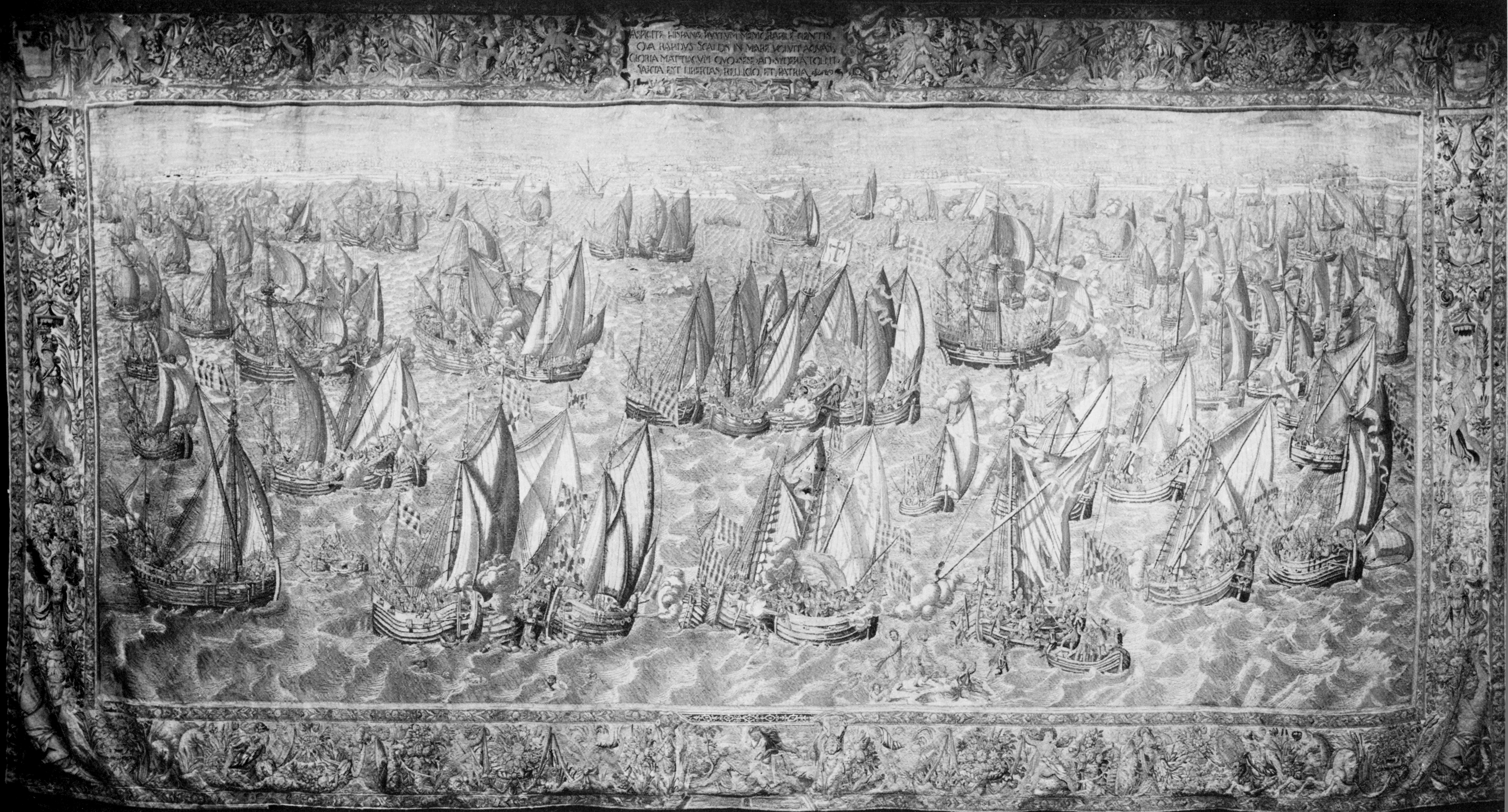 Hendrick Cornelisz. Vroom (design) and Francois Spierincx (weaving). The Battle of Bergen op Zoom, finished 1595. Zeeuws Museum, Middelburg, the Netherlands. After the seabeggars had successfully blocked the harbor of Amsterdam, they defeated a Spanish fleet under the command of Maximilien de Hénin- Liétard, Count of Boussu, in the battle of the Zuiderzee in 1573. Because the seabeggars kept on pirating Dutch fishing boats and neutral merchant vessels, even though their letters of marque entitled them only to take actionp. 10 against the Duke of Alba, one can hardly call them a regular war fleet.14 But because they pursued the political aim of driving the Spaniards out of the Netherlands, they can be seen as the medium that turned the revolt of 1566/1567 into the beginning of the war of independence.15 The seabeggars were a medium in the sense that they—like chora—disappeared from the stage once maritime space began to dominate the political representation of the General States. And they were a medium, too, in the sense that their status kept oscillating between regular war fleet and irregular pirates.
On some of Vroom’s images we can discern the operative means by which the independence of the new state was eked out. These were mainly retooled boeiers, vlieboats, and flutes. Boeiers are small single-masted sailing boats able to navigate the tidelands. Vlieboats, the privateers of the seabeggars, are specialized craft with low draft used to navigate in shallow waters such as the vlies between islands, channels (gats), or estuaries. Because the vlieboat is so small and maneuverable, pirates of other nations soon adopted it. The flute is an improved form of the vlieboat that emerged from the “small war” of the seabeggars against the Spaniards.
The state of the Netherlands was born not from the appearance of a superhero called Leviathan, who—as in Thomas Hobbes’s theory concerning the formation of the state—is produced by contracts between persons in the legal sense. Rather the state came about because of the flocking together of boeiers and vlieboats, which do not organize themselves in the form of a naval unit but emerge here and there as an amorphous mass. Large galleys, carracks, or galleons perhaps more readily serve as allegories of the state. Boeiers and vlieboats, on the other hand, do not easily lend themselves to allegories or emblematic appearances of sovereign actors on the stage of history. An engraving known as The Fleet Landing in Philippine (1600) by Cornelis Claeszoon, after a drawing by Vroom, shows how that shapeless iconoclastic Figure 5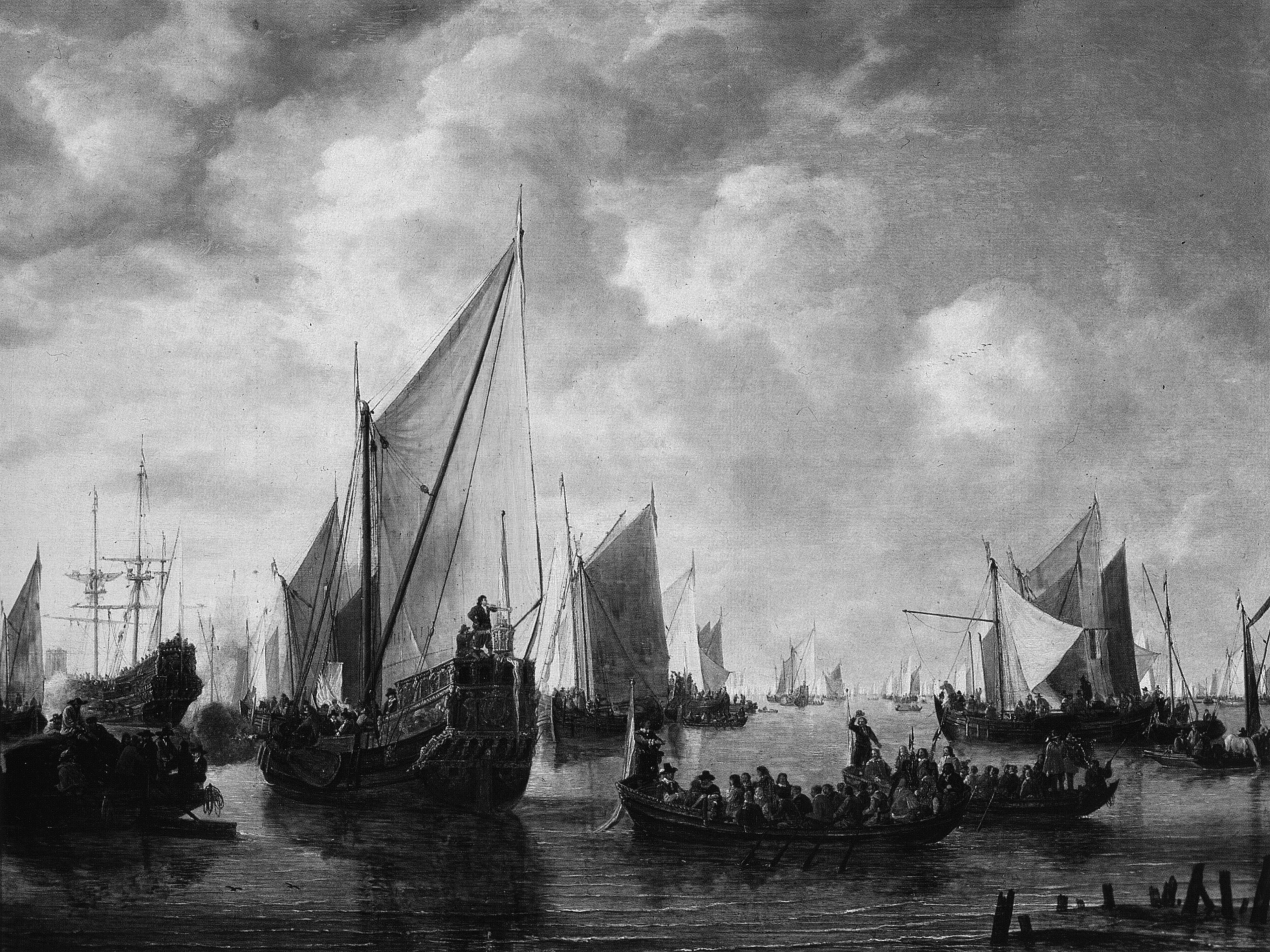 Simon de Vlieger. The Disembarkment of Prince Frederic Henry of Orange, 1649. Oil on oak wood, 28 x 36.25 in. (71 x 92 cm), Kunsthistorisches Museum, Vienna. power looked when it appeared within the field of representation.16 The image depicts the landfall, near the village of Philippine in Flanders, of the fleet of Maurice of Nassau, Prince of Orange, which consisted of 2,800 boats. One might be tempted to classify this image as a forerunner of allegorical representations of state power and national wealth such as thep. 11 extraordinarily large engraving s’Lans Welvaren from 1613, which shows the panorama of Amsterdam from the sea side.17 Against the backdrop of the city, the welfare of the country, which results from maritime trade, is emblematized. In contrast with s’Lans Welvaren, in The Fleet Landing there is only a mass of cutters, vlieboats, yachts, and boeiers that knows neither center nor direction and forms a forest of masts and sprit sails as it spreads toward the coastal strip. The small vessels of the seabeggars do not form a unit, nor do they form a readable text as they do in the armada tapestries. Instead they are undifferentiated, a sea of boats, a tidal wave that will befall the land.
This piratical noise at the bottom of history would soon be superseded by representations in which the former ships of the seabeggars become part of the representation of sovereign acts of state. The seascape must be read as a screen memory in the Freudian sense; it screens that which no sovereign, once he has entered the stage of world history as a legal person, wishes to remember. Soon the stories of pirate attacks that made no difference between friend or foe would be replaced by founding narrations that talk of secret meetings at which oaths are sworn, declarations of Figure 6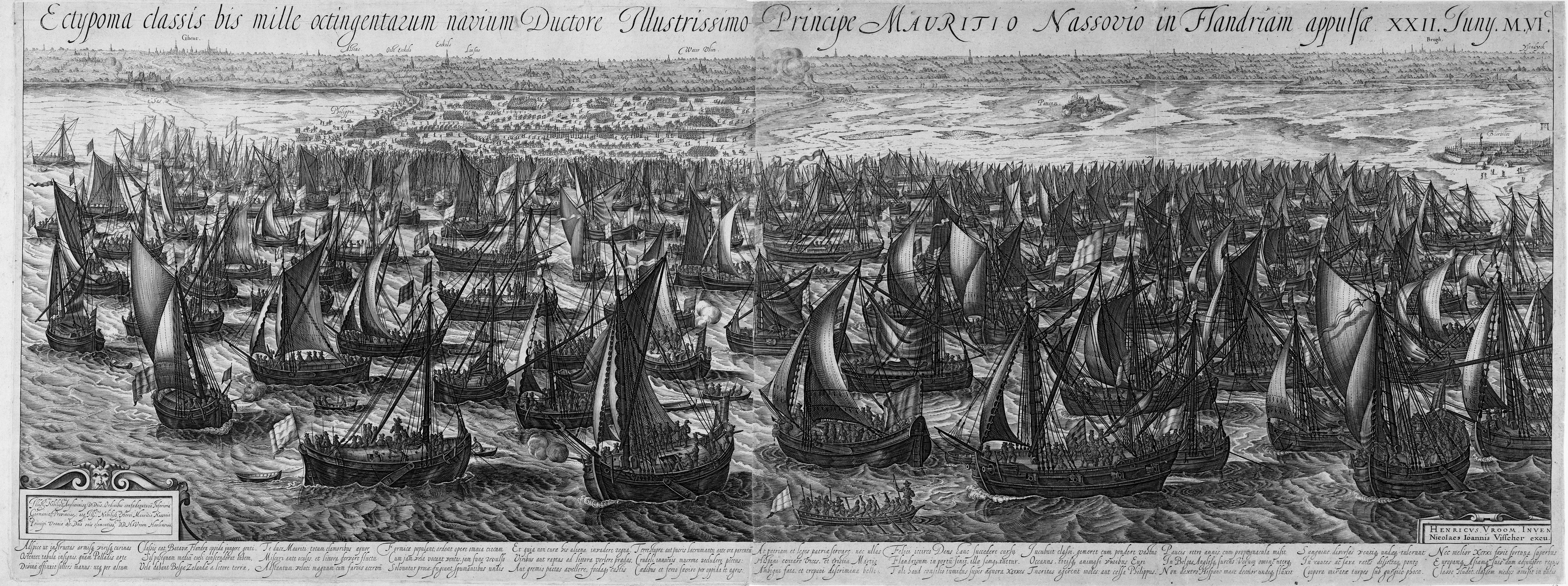 Cornelis Claeszoon after Hendrick Cornelisz. Vroom. The Fleet Landing in Philippine, or Ectypoma classis bis mille octigentarum navium Ductore Illustrissimo Principe Mauritio Nassovio in Flandriam appulsa. XXII Juny M.VI.C, 1600. Copper engraving with two plates, 15 x 38.6 in. (38 x 98 cm). Rijksmuseum, Amsterdam. Figure 7
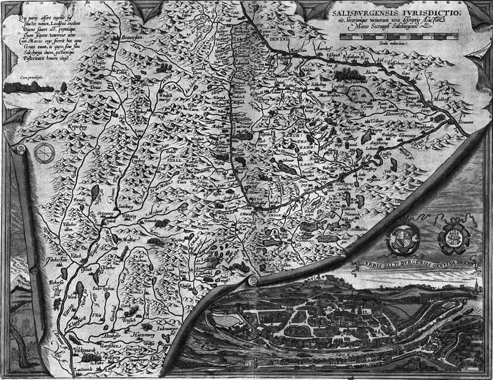 Marco Secznagel (inventor). Salisburgensis lurisdictio. From Abraham Ortelius, Theatrum Orbis Terrarum (Antwerp, 1570). p. 12 independence issued, and political representatives elected.18
The undifferentiable swarming of boeiers and vlieboats, which once appeared on Vroom’s Fleet Landing, soon gave way to allegorical representations that expressed the new political self-image of the cities, which expanded their sphere of control to the oceans. See, for instance, Vroom’s Gezicht op Hoorn from 1622 or Simon de Vlieger’s painting from 1649 showing the disembarking of the Prince of Orange. The jaght turned into the statensyacht, a type of a vessel and the preferred motif of numerous Dutch seascapes. As the name, which means “hunt,” indicates, a jaght was a small privateer, esteemed because of its speed. The statensyacht, however, does not hunt; it exists only for the representative purpose of transporting heads of state and war heroes from the pier to their ships and vice versa. The statensyacht is a metaphor in the literal sense: it constitutes the transmission between the state and its symbol, the ship of state. A monstrous sort of ship, the statensyacht combines a former pirate’s vessel with a monumental adornment at its stern. What originally was meant to become invisible in situations where land and sea get confused, appears now as a vehicle for representative acts of state on the mirror of the sea, now degraded to serve the needs for representation of a state that rules the waves.
Topographic Panorama
Views Vroom knew the panoramic views of landscapes seen from a bird’s-eye perspective from the genre of city panoramas, which gained popularity in the Netherlands in the middle of the sixteenth century. In the second half of that century the Netherlands became the most important center for cosmography and cartography in Europe.19 Antwerp in particular became a hot spot for geography. From there atlases, land charts and ocean maps, globes and cosmographic descriptions were sent into all corners of the known world. The transitions between art and science were fluid, especially in the case of maps. Atlases and maps were produced and sold by the same publishers who produced and sold graphic representations of art. The science of cartography and even the production of marine paintings drew on the knowledge of Dutch sailors, at least for a short period.
The condition under which biblical bodies of water—as represented in latemedieval baptisms of Christ, Saint Christophoruses, Miraculous Drafts of Fishes, and so on—could turn into “maritime spaces” was “the relationship between ships and cities,” which (according to Sekula) was first established in Dutch marine painting.20 To make the sea a site for images, the sea had to become part of a municipal economy that increasingly operated on a global scale. The city appeared inverselyp. 13 as a representation of a borderless polis that extended without limit its influence by means of floating fragments of its territory.21
Preceding the type of seascape that combines a city profile with ship portraits— a type of seascape that became very popular during the seventeenth century—are panoramic topographies: the Venice woodcut by Erhard Reuwich in Bernhard von Breydenbach’s Peregrinatio, Jacopo de’ Barbari’s monumental copper engraving of Venice, a view of Antwerp by the hand of a Flemish master from 1515 (another woodcut), and the monumental Civitates Orbis Terrarum by Georg Braun and Frans Hogenberg.22
What these panoramic city views have in common with marine charts is a dual perspective. The raised horizon and the bird’s-eye perspective that makes it possible to read the city view like a map were combined with ship portraits that were presented in side elevation as seen from a much lower viewpoint. The ship portraits of Pieter Breughel the Elder, which for the main part were engraved by Frans Huys and published by Hieronymus Cock in Antwerp, soon became the standard for ship portraits in very different media. Several sheets of Breughel’s Suite des vaisseaux de mer (1565) became models for the representation of ships on maps; for instance, in Abraham Ortelius’s Theatrum Orbis Terrarum of 1570.
One can find numerous examples of representations that feature a dual perspective in Ortelius’s Theatrum. The sheet dedicated to the view of Salzburg demonstrates that the inventors were quite conscious of the antagonism between the desire for the cartographic and the desire for the panoramic view. The draftsman uses the illusionism of trompe l’oeil to integrate both perspectives in one homogeneous image. Thus, he succeeds in mastering the dual perspective in a logical way without overcoming it (which he presumably never intended).
The seascape therefore presupposes the overcoming of the dual perspective. To generate a uniform maritime space, the bird’s-eye perspective of the city view has to merge with the perspective of the ship portrait, which is achieved by lowering theFigure 8 Lucas Jansz. Waghenaer. Thresoor der Zeevaerdt (Leiden, 1592). Map of Zeeland, detail. p. 14 horizon and thereby turning the city view into a city profile, which approximates a line the further the profile is shifted toward the horizon.
The cleavage of the dual perspective system is not overcome by consequence of a hypothetical pressure in the history of style toward more realism. As demonstrated by the dualistic view of Salzburg in the Civitates, one could combine the different views without producing an image paradox. The heterogeneous spaces were integrated aesthetically and politically into one maritime space only because the city profile became part of a practice of navigation that was closely connected to the navigational operations of the sea beggars.
Lines of Sight
In Lucas Jansz. Waghenaer’s Thresoor der Zeevaert from 1592, one finds the following instructions for sailing into the mouth of the river Scheldt and therefore up to Antwerp through the Wielinge, a swash channel between the sandbanks east of the mouth of the river:
If you want to sail into the Wielinghe, coming from the west, set a course toward the tower of Oostende … , repeatedly read seven fathoms, but then you have to look out for the shoals in front of Wenduine; go east to north and east north east until Lissewege comes into sight within Blanckenberge and until the house Ter Doest is a ship’s length afar from Lissewege in the south, then you are in the mouth of the Wielinge. Then put Westchapel close to the eastern end of the church of Heyst, and you are on a good course… . If the fire boat of Heist touches the church of Heist, you will not sail across the polder. If you see the tower of Middelburg one line off east and in the south the tower of the city hall, then you are sailing the best deep water of the Wieling… . But if you want to sail through the shallow waters of this entrance, you should know, that you reach the eastern end of this sandbank when you see Aardenburg stand against the bank of Cadzant, and that the sandbank extends so far until Knokke goes through Westchapel… . But if the fire boat of Blanckenberge comes to stand right above the city hall of the said place, you are running right across the sandbank… . And if you want to sail into the Zwijn [i.e., to Bruges], you should place Aardenburg a handspike’s length from the castle of Sluis and the cloister of Santa Anna over the schapestel (of Schapenbrug), then you are close to the horse market: let then all buoys on starboard and all station poles on larboard if you want to sail inside.23
p. 15
Described here is a practice of coastal navigation that has nothing to do with the determination of one’s position by means of latitude and longitude, nor with the use of Jacob’s staff, quadrant, and astrolabe. Instead what is described is navigation by means of sight lines, whereby readings of the compass are joined with the observation of landmarks and soundings. The pilot finds his position, or the precise moment when he has to tack or to jibe, by visually locating landmarks such as church steeples, towers of city halls, and navigational aids like floating lights and station poles, either above or next to each other. Navigation by means of lines of sight is thus based on the movement of the ship, which causes an apparent movement of the landmarks and their relative distance. This kind of navigation makes use of the optical effect that distant objects appear to reside on one and the same visual plane. Thus the length of a sandbank can be determined by waiting for the moment when a certain landmark (e.g., Knokke) moves apparently through another one (e.g., Westchapel). Precisely that which becomes lost if one tilts a map or some other vertical topographical perspective into an extreme horizontal view—that is, the possibility of determining the distance between two points—is turned into a practical benefit by this method of navigation. That ships and towers come to hide other ships and towers was an optical phenomenon that draftsmen of sea battles or city panoramas tried to avoid by all means in the sixteenth century. But pilots appreciate and make use of precisely this optical phenomenon when they navigate the shallow waters of Zeeland and Holland. Here, ships are everywhere threatened by droochts, sants, and gronts (shoals, sandbars, and grounds) as they try to find the gats and vlies (passages) to the harbors that are located in the arms of the Rhine delta or in the Zuiderzee. The job of the pilot is supported by a large-scale map on which the bearings or lines of sight mentioned in the sailing instructions are recorded. The design of these maps features the striking detail of coastal profiles that are drawn along the coastlines and inform the pilot about the appearance of the coast and the landmarks. The dual perspective that is so typical of maps of this time—for example, those by Abraham Ortelius—or of the topographic city views published by Georg Braun and Frans Hogenberg, appears here to fulfill a practical function. Waghenaer’s use of dual perspective is not like that of Jacob van Deventer or other draftsmen who worked for Ortelius or Braun and Hogenberg; that is, he combines cartographic overview with the visual experience of a landscape not for aesthetic reasons but to aid navigation by means of lines of sight. This Figure 9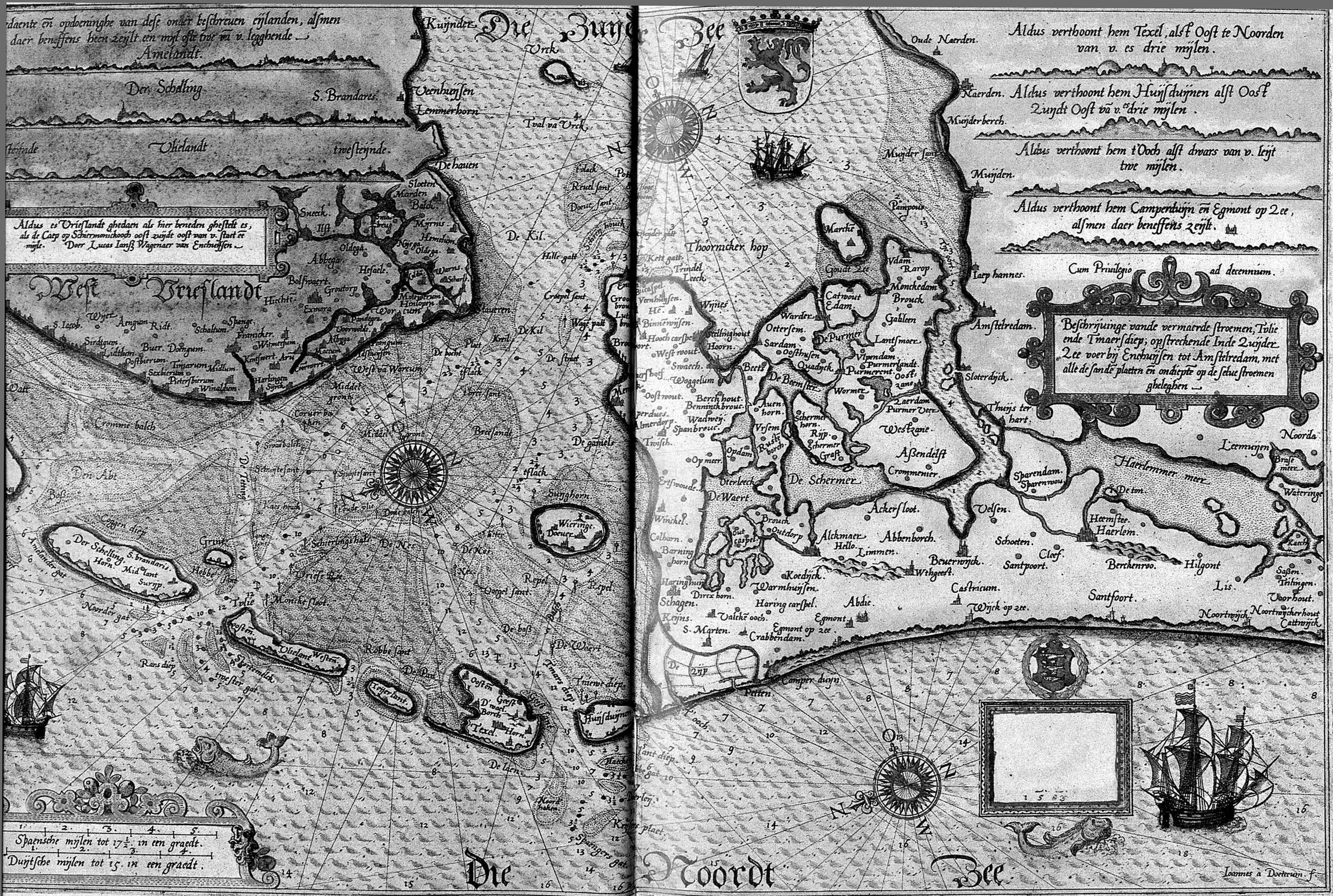 Lucas Jansz. Waghenaer. Spieghel der Zeevaerdt (Leiden, 1584). Map of Zuiderzee. feature is typical of the maps of Waghenaer. However, the coastalp. 16 profiles that look like curled rims of the mapped mainland are poor in detail because of their small scale and are thus of only minor value to the pilot who sails close to the coast. This is why Waghenaer integrates coastal profiles of especially dangerous passages in the maps of his Spieghel der Zeevaerdt. And in Thresoor der Zeevaerdt he inserts coastal profiles directly above or below the sailing instructions to inform the pilot as precisely as possible about the appearance of the coast.
Waghenaer was actually not a cartographer but a pilot from the city of Enkhuizen, on the west coast of the Zuiderzee. His life and work was closely connected to the business of the seabeggars, those uncanny beings who practiced the spaceconstituting chorein of navigation by means of lines of sight in the gats and vlies. During Waghenaer’s lifetime, Enkhuizen, once a small fishing harbor, became a city of 16,000 inhabitants. Ships from India, East Asia, and the West Indies moored in its port. Soon after the seabeggars started attacking Spanish ships and raiding harbors loyal to the Spaniards, Enkhuizen fired its magistrate of regime loyalists and handed the city to William of Orange.24 Enkhuizen controlled all commercial traffic to and from Amsterdam and profited from the gains of the overseas trade as well as from the ransom and captured merchandise of the pirates. After Waghenaer lost his position as a collector of license fees in the harbor of his hometown, apparently because part of the booty of the seabeggars found its way into his pockets, he made use of his drawing talent and started to publish his professional knowledge about the navigation of the coastal waters of Northern Europe in the form of specially designed maps, coastal profiles, and sailing instructions.25
The author of the Thresoor der Zeevaert would eventually add to his name the specification, “Stierman woenende binnen Enckhuysen” (pilot living in Enckhuysen).26 Thus, what we find in Waghenaer’s opus is not the perspective of the geographer who perceives a territory as a surface seen from above but the perspective of a pilot who stands at the helm of a kaag, a boeier, or a vlieboat and for whom a territory Figure 10 Lucas Jansz. Waghenaer. Thresoor der Zeevaerdt (Leiden, 1592). Coastal profile. Figure 11
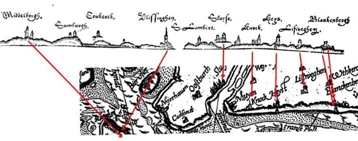 Lucas Jansz. Waghenaer. Thresoor der Zeevaerdt (Leiden, 1592). Diagram mapping the profile of a part of the coast of Flanders onto the corresponding section from the map of Zeeland. p. 17 offers the sight of a coastal strip that barely rises above the horizon.
Nevertheless, one encounters strange irregularities if one cuts out the coastal profiles that appear on Waghenaer’s so-called pascaerten and rotates them in such a way that one can compare them point by point with the horizontal coastal profiles from the Thresoor der Zeevaerdt. Take, for instance, the Zeeland map from the Thresoor der Zeevaerdt and the corresponding diagram that shows the coastal profile belonging to the sailing instruction for the passage through the Wielinge. Whereas in both coastal profiles the intervals between the landmarks of Blankenberge, Lissewege, Heist, and Knokke match in an almost precise fashion, an enormous distortion occurs at the moment our imaginary vessel enters the mouth of the river Scheldt. The two towns of Vlissingen and Middelburg, which are placed one above the other on the map and therefore should appear one behind the other on the diagram, appear separated from each other by an enormous lateral interval that contains three additional church steeples not recorded on the map at all. How can this distortion be explained? My thesis is that the diagram of the coastal profile does not represent the coast as it would appear to a sailor under the assumed conditions of central perspective but is piecewise as seen from various perspectives from different directions as it would appear successively to a pilot on a vessel that sails along the coast. What we see on the left of the entrance into the Scheldt is not the view of a coast as it would appear to a sailor who has looked from a northwestern direction onto the segment of the coast between Blankenberge and Sluis but the view of the coast of Zeeland first from a much closer distance and second as seen Figure 12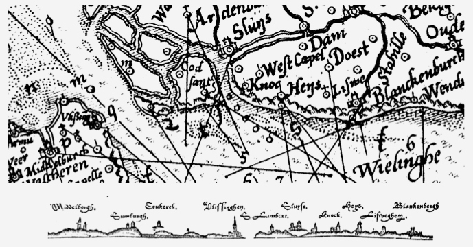 Lucas Jansz. Waghenaer. Thresoor der Zeevaerdt (Leiden, 1592). Map of Zeeland, detail. Diagram showing the rotation of the lines of sight by which the distortion of the coastal profile left of the mouth of the river Scheldt is explained. The dotted line indicates the course of the ship. Figure 13
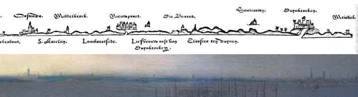 Profile of the coast between Dunkirk and Ostend from Lucas Jansz. Waghenaer. Thresoor der Zeevaerdt (Leiden, 1592). p. 18 from the southwest, which implies a rotation of nearly 90 degrees to the left. This corresponds to the lines of sight that are plotted in Waghenaer’s pascaerte. Different perspectives have been integrated in one and the same diagram of the coastal profile. We must not perceive the diagram of the profile as a result of a projection of the coastal profile according to the laws of central perspective as we would see it from a fixed position and a unified angle of sight. Rather we must see it as a piecewise projection of a curvilinear trajectory onto a plane that accounts for the tacking of the ship into the mouth of the Scheldt.
The maritime space of the Dutch seascape was constituted by a perspective that was informed by the practice of navigation by lines of sight. What looks like a panoramic view of a coast that appears above the horizon on Vroom’s painting The Seventh Day of the Naval Battle is in fact a module taken from Waghenaer’s Thresoor der Zeevaerdt. The coastal profile in the painting corresponds exactly to the diagram of the coastal profile that represents the coast between Dunkirk and Ostend.27 One can even insert it into the painting in such a way that the two profiles match each other. A comparison with Waghenaer’s Kaart van de Hollandse kust, which also contains the corresponding segment, the panoramic view of which appears in Vroom’s Seventh Day, produces evidence that the diagram of the coastal profile between Dunkirk and Ostend—and hence also Vroom’s coastal panorama—does not feature such extreme mappings of perspectival turns as the coastal profile between Blankenberge and Middelburg. But one has to concede as fact that Vroom’s coastal panorama is the result of a simultaneous alignment of nonparallel and successively taken bearings along lines of sight. What we do, if we interpret Vroom’s coastal panorama as an object in the sense of modern metaphysics (which, according to Heidegger, grants the status of being only to something that can be represented as an object) is exactly what Valérie November, Eduardo Camacho-Hübner, and Bruno Latour have criticized in their recent text on cartography and navigation:
we might have confused in the past two entirely different meanings of the word
“correspondence”: the first seems to rely on a resemblance between two elements
(signs on the map and territory, or more philosophically words and worlds);
while the second emphasizes the establishment of some relevance that allows
a navigator to align several successive sign posts along a trajectory.28
Latour and colleagues are right, too, when they note that, as a consequence, “maps have been aesthetized and fused with the emerging culture of ‘realistic’ paintings.”29 But they are wrong when they credit or discredit “Dutch painting” with the honorp. 19 of being the culmination of “perspective painting” and hold it responsible for having replaced a notion of maps as trajectories of successively processed operations with a mimetic or representational notion of maps.30 Vroom’s painting indicates that the first Dutch seascapes are based not on the laws of mathematical geometry but on a cultural technique of a piecewise recording of different bearings rooted in the pirate’s knowledge of warfare in coastal waters—knowledge that is conserved and pacified in the realism of realistic representation.
If my thesis is correct, this would mean, first, that the horizon in Dutch seascapes is not the same as the horizon on paintings that were created under the conditions of geometric perspective construction south of the Alps: a technical factor that is the optical, mathematical, and philosophical condition for the construction of the image as such.31 The horizon in the Dutch seascape must, on the contrary, be conceived as an immanent object within the image: a coastal panorama asymptotically approaching a line. Second, what in Vroom’s early seascape seems to be a panorama seen from one fixed standpoint turns out to be the result of a parallel alignment of nonparallel, successively traversed lines of sight. The seascape records, hides, and pacifies the chorein of the pirates/pilots; that is, the experience of the operational space of the navigators is kept latent, in the background of a topographic space represented for the sovereign subject seated in his theater loge.
The silencing of the pirate’s chorein by the rise of the imperial nation-state and its aesthetics made room for an aesthetics of political allegories and the capitalist sublime of the unlimited maritime space. A view on the origin of the seascape that refers art history not to a teleological development of realism but to a history of cultural techniques like navigational practices discovers that the seascape is not based on Euclidian laws and their legal implications but on the troublesome compromise between banishing and at the same time latently conserving the chorein of the sea beggars.
Figure 14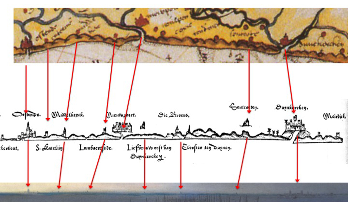 Diagram showing the correspondence between landmarks on Lucas Jansz. Waghenaer’s Kaart van de Hollandse kust (Map of the coast of Holland) from Descriptio orae maritimae Frisiae orientalis et occidentalis (ca. 1592; detail, rotated eighteen degrees to the left), on Waghenaer’s profile of the same part of the coast from Thresoor der Zeevaert, and on Vroom’s view of the same part of the coast in The Seventh Day of the Naval Battle between the Spanish Armada and the English Fleet.
p. 20
Figure 15
p. 21

